3D Geodata Academy

Point Cloud Processing

The craft of turning billions of points into structured knowledge. Filtering, segmentation, clustering, and feature extraction workflows, all with hands-on Python code.

Dr. Florent Poux

Curated by Dr. Florent Poux

19 in-depth guides

Point Cloud Processing

The craft of turning billions of points into structured knowledge. Filtering, segmentation, clustering, and feature extraction workflows, all with hands-on Python code.

3D Mesh from Point Cloud: Python with Marching Cubes Tutorial

By Dr. Florent Poux, PhD in 3D geospatial sciences | Author, 3D Data Science with Python (O’Reilly) | Published 28 February 2025 This tutorial dives deep into the Marching Cubes algorithm, a powerful technique for meshing 3D point clouds using Python. We transform a point cloud into a 3D mesh, experiment with various parameters, and […]

3D Mesh from Point Cloud: Python with Marching Cubes Tutorial Read More »
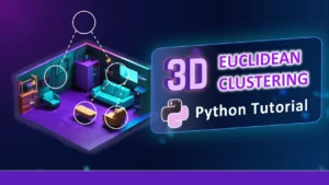
3D Euclidean Clustering Tutorial Cover

Python Guide for Euclidean Clustering of 3D Point Clouds

By Dr. Florent Poux, PhD in 3D geospatial sciences | Author, 3D Data Science with Python (O’Reilly) | Published 29 November 2024 Python Tutorial for Euclidean Clustering of 3D Point Clouds with Graph Theory. Fundamental concepts and sequential workflow for unsupervised segmentation. As you are developing the next generation of AI systems, you face a […]

Python Guide for Euclidean Clustering of 3D Point Clouds Read More »

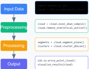
3D point cloud workflow

A Quick Dive into Modern Point Cloud Workflow

By Dr. Florent Poux, PhD in 3D geospatial sciences | Author, 3D Data Science with Python (O’Reilly) | Published 4 November 2024 Designing a point cloud workflow is a powerful first-hand approach in 3D data projects. This article explores how processing massive point clouds efficiently isn’t about having more computing power. It’s about being more […]

A Quick Dive into Modern Point Cloud Workflow Read More »

3D Shape Detection with RANSAC and Python (Sphere and Plane)

By Dr. Florent Poux, PhD in 3D geospatial sciences | Author, 3D Data Science with Python (O’Reilly) | Published 19 July 2024 RANSAC detects spheres and planes in noisy 3D point clouds by repeatedly fitting a candidate model to a random sample of points and keeping the fit that explains the largest number of inliers. […]

3D Shape Detection with RANSAC and Python (Sphere and Plane) Read More »

Aerial LiDAR Point Cloud Feature Extraction Tutorial

Point Cloud Feature Extraction: Complete Guide

By Dr. Florent Poux, PhD in 3D geospatial sciences | Author, 3D Data Science with Python (O’Reilly) | Published 24 January 2024 This tutorial targets 3D Point Cloud Feature Extraction for developing an interactive Python Segmentation App. The goal is to develop an end-to-end system that can abstract complex point clouds with pertinent features. These […]

Point Cloud Feature Extraction: Complete Guide Read More »

Point Cloud Processing for geometric and semantic interpretation

By Dr. Florent Poux, PhD in 3D geospatial sciences | Author, 3D Data Science with Python (O’Reilly) | Published 5 March 2022 A Story of Point Clouds and Perception Foreword on the 3D conference This 9th International Workshop 3D-ARCH focused on “3D Virtual Reconstruction and Visualization of Complex Architectures”. It started in 2005 in Venice and […]

Point Cloud Processing for geometric and semantic interpretation Read More »

point cloud segmentation

Learn 3D point cloud segmentation with Python

By Dr. Florent Poux, PhD in 3D geospatial sciences | Author, 3D Data Science with Python (O’Reilly) | Published 14 May 2021 Learn 3D point cloud segmentation with Python A complete python tutorial to automate point cloud segmentation and 3D shape detection using multi-order RANSAC and unsupervised clustering (DBSCAN). If you have worked with point […]

Learn 3D point cloud segmentation with Python Read More »

Scroll to Top