This article provides the best recommendations and directions for every dataset, tool, software, hardware, code setup, and library for 3D Reconstruction Methods. This is the first Chapter of the 3D Master Toolbox, which provides 47 methods and AI tools for 3D. This article shares online solutions for 3D Data Curation (multi-modal 3D asset, various data source), 3D Data Acquistion (methods, hardware and price) and 3D Generative AI.
I love the following sentence and how amazingly generalizable it is:
“A good tool improves the way you work. A great tool improves the way you think.” — Jeff Duntemann
You can think of tools like a hammer for nails or the latest VR headset for 3D Data Immersive Experiences. And this stretch is fantastic!
But I have noticed many of us struggle to know where to start when it comes to 3D Data and Artificial Intelligence (AI) systems. Which tools should constitute your toolbox? Which workflows are important to follow?
It becomes overwhelming to select between the dozens of software, licenses, and AI solutions out there.
So what essentials should we bring in our “3D backpack”?
This is precisely the goal of this article: To share with you the Ultimate 3D Data Workflows, Software, Hardware, and AI Toolbox.
After more than 13 years in the space, let me share my two cents with a selected few: 47 Tools and Methods.
However, listing the 47 elements would be a bit bland and hinder my ability to help develop your ability to innovate with 3D. Therefore, the key to solving this challenge is to break it down into manageable buckets.
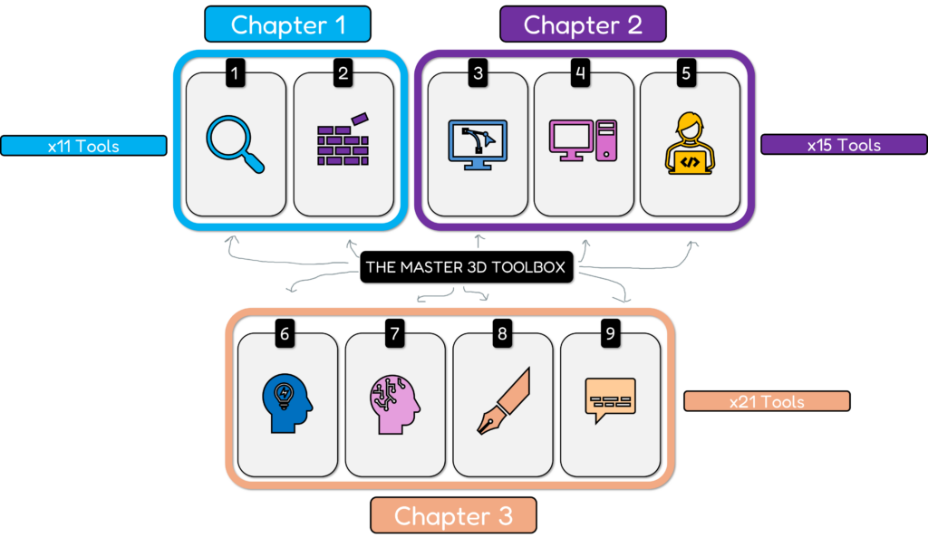
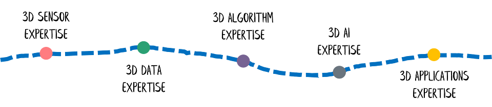
And I am thrilled to say that I have a proven strategy to develop a master 3D data toolbox with only 9 buckets as illustrated below.
I’ve personally been using it consistently with various teams I manage at the University or for R&D Tech Companies, and it works. It allow you to create anything, from an entire city reconstruction engine to a single intricate product design.
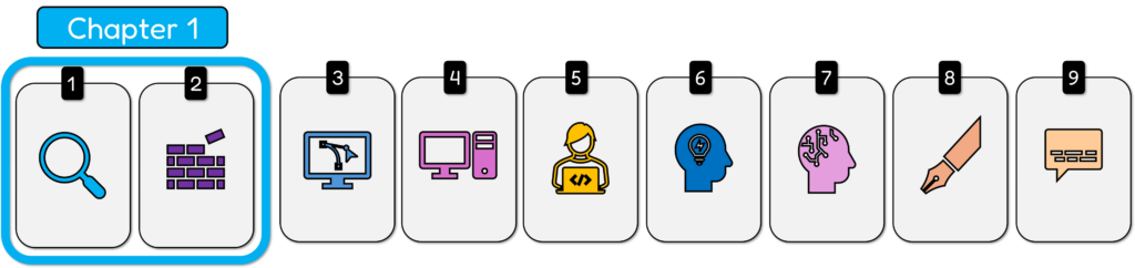
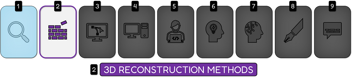
Chapter 1: 3D Reconstruction Methods and Toolbox
These nine 3D buckets — ranging from data curation and reconstruction to coding, AI tools, and communication — are absolutely essential because they encompass the entire spectrum of 3D data processing, from the initial data gathering all the way to sharing results with your audience.
To make the experience even better, I split this into a serie of three chapters that focus on a specific set of buckets as seen below.
Having a structured approach to each of these buckets provides you with the required tools, workflows, expertise, and strategies that you need to build and maintain any type of 3D project.
It is not only about getting access to the tools but also about understanding all the concepts and how they connect. This framework is designed to cover all of the components of 3D data workflows to ensure you have both the practical know-how and the conceptual understanding to master the 3D space.
It’s not just a collection of tools; it’s a holistic approach to turn your ideas into real results, while also keeping track of all of the new advancements in the space.
🦚Note: These are the pillars of 99% of my workflow. I’ve put them into action with my teams and with success for major projects to solve significant challenges in 3D data science. At the end of the article, I compiled various resources that focused on each aspect independently.
This article focus on the first two buckets, and constitute the Chapter 1 that touch on 3D Reconstruction Methods as illustrated below.
Let’s break down each bucket.
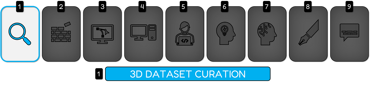
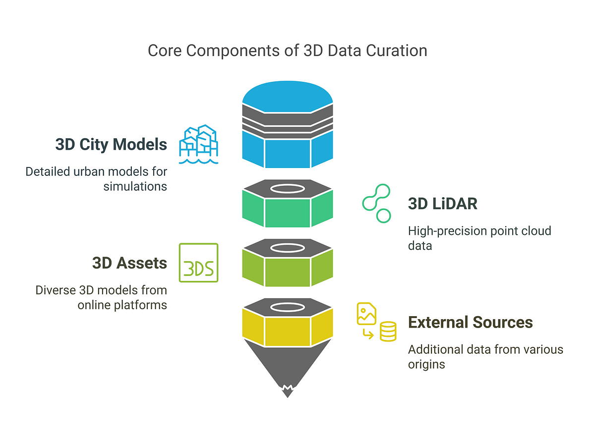
3D Dataset Curation (1 to 4)
The first step in the 3D data journey is how you source the relevant data, and this is critical because it dictates the outcome of all downstream processes.
The goal is to obtain high-quality, relevant datasets to drive meaningful results. This process entails identifying data sources, evaluating their suitability, managing data formats, and guaranteeing data integrity, all while closely monitoring data licenses and privacy policies.
To start small, let me share four data sources where you can get your hands on 3D data (or relevant data). Let me share some tools and solutions for each 3D Data Curation Method.
1. 3D City Models (3DCityLoader)
Getting our hands on 3D City Models is not the easiest road. But we are getting there, thanks to the strategic plans of our nations and 3DCityLoader (among others).
This is an excellent service that I recently started using as part of my scientific activities. 3Dcityloader converts 3d city data from public sources into practical file formats like CityGML, STL, or OBJ. The service’s data comes directly from the respective cities, which usually provide it as CityGML. The detail level is, therefore, much higher than with other sources, like OpenStreetMap. It allows me to build new experiments fast, where 3D geospatial elements can be easily integrated into various software (see Bucket 3: C.).
2. 3D LiDAR Data (Point Clouds)
This is my favorite data modality. And you can get a lot of 3D point clouds from the web.
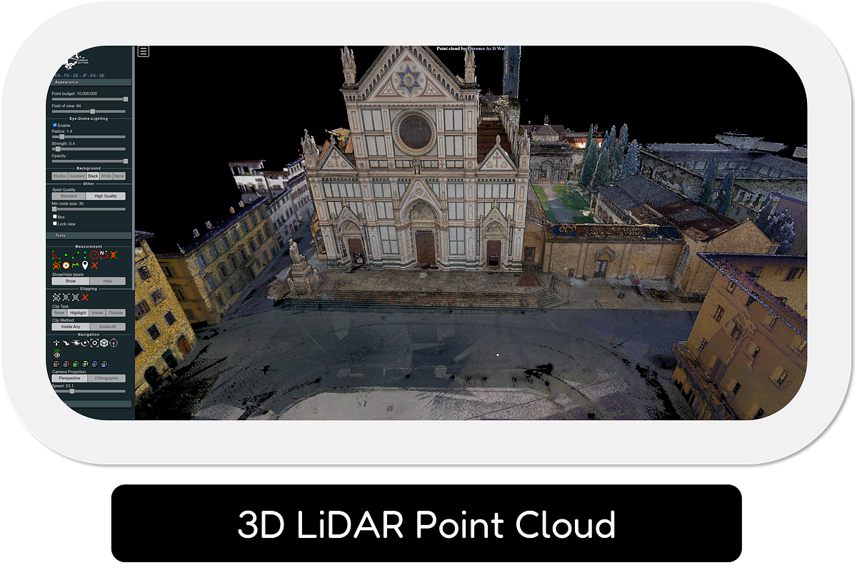
For example, my core objective when using OpenTopography (or Opendata repositories) is to find and get access to large-scale LiDAR datasets for geospatial analysis. I use this service when I want to leverage point clouds for scientific research, from terrain analysis to mapping. It offers a vast collection of LiDAR data, that I often need to understand the dynamics of the earth surface. It helps to streamline my research by providing all of the data I need all in one place.
You can also source national opendata initiatives, such as LidarHD in France, or even sources such as https://openheritage3d.org/ to get your hands onto terrestrial laser scanner data of heritage sites (among other things) or a little Gem (close to my heart): Florence As It Was.
3. 3D Assets (Sketchfab / TurboSquid)
When I visit Sketchfab or TurboSquid, my main goal is to find specific, high-quality 3D models or assets for my projects, where I can find a massive number of options.
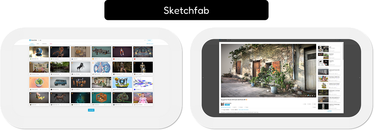
I usually go there when I need a unique asset with particular format and textures. The best thing about thes platforms is that it provides different categories, licensing options, and it also allows for direct integration into many 3D software. I can find anything, from a simple component to a full 3D scene.
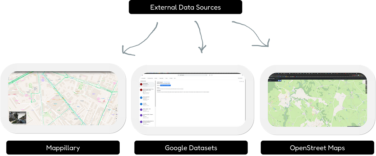
4. External Data Sources
For Geospatial applications, you often need external information, from other non-3D modalities. This is where I tap into external sources such as Mappillary, OpenStreetMap, or the Google Dataset Search engine. From there, you can get access to a range of data that is not easily available on other dedicated platforms.
I use Mappillary for 360 imagery, OpenStreetMap for vector data, and Google Dataset Search for diverse research datasets. This allows me to construct highly realistic urban scenarios and source any data necessary for my research. These external sources serve as complementary sources to my core databases of 3D models or LiDARs, ensuring I have access to all the necessary components.
Bonus: This would not be complete without citing my various Tutorials on Medium which share 3D datasets with open licenses, such as the one below (you can play around with the 3D point cloud on the web: WebGL Real-Time 3D).
🌱Growing: Current research focuses on creating automated data curation pipelines to reduce manual effort, while enhancing data quality. This includes using AI tools to clean data, check its quality, and change its structure. Another area of study is creating data storage for 3D assets. This uses clear data descriptions to make it easier to find the assets. Also, with the advent of Generative AI, there is a new focus on building datasets to train this very new type of AI architecture, which requires a lot of carefully crafted and tailored datasets.
These constitute your four ideal sources for 3D Data.
Now, let us talk about the 3D reconstruction methods or how to generate these 3D datasets.
3D Reconstruction Methods (5 to 11)
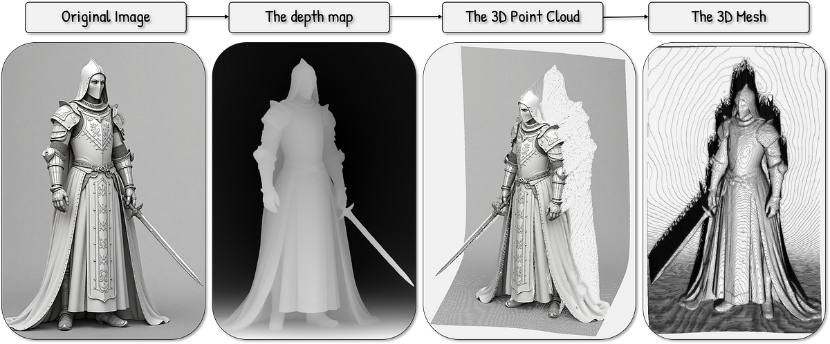
3D reconstruction involves creating 3D models of physical objects from sensors (images, laser scanners, lidar), and other techniques (such as 3D Generative AI).
In modern 3D data capture, the central two concepts are image-based methods (photogrammetry), which leverage several images to derive a 3D model, and laser-based methods (LiDAR), which measure distance and angles to reconstruct 3D shapes.
The hardware used includes cameras, laser scanners, or range cameras. These systems capture the physical measurements, while software algorithms work in the background to reconstruct the subject’s geometry and appearance.
Another approach is 3D Generative modeling. With that, you can use tools like Microsoft Trellis, to generate data with image or text prompts. This usually is pure inference work and is not directly measured like with LiDAR. Below is an example I made using Python and this 3D Master Toolbox.
To summarize, you can get powerful systems working with these 3 main categories:
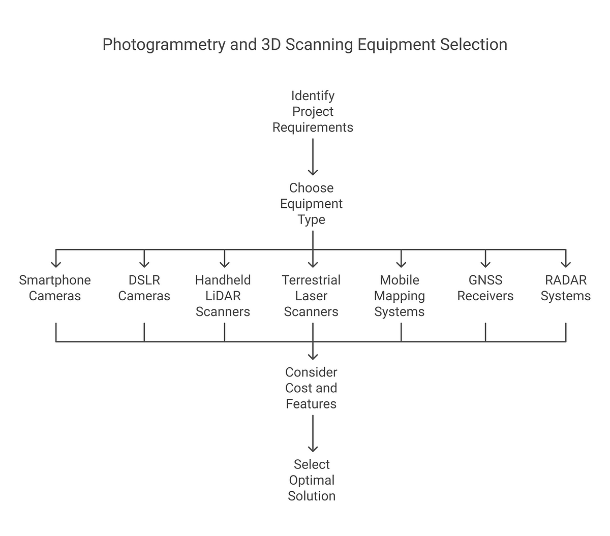
Now that we delineated the core 3D Reconstruction Methods, I would like to share some hardware recommendations (5 to 11) for your 3D reconstruction projects, sorted by affordability.
5. Smartphone Cameras for Photogrammetry (3D Reconstruction Methods)
These cameras are enough for a quick 3D reconstruction when accuracy is not the most critical factor.
Especially for a quick 3D reconstruction when accuracy is not the most critical factor, smartphones are a good choice. I use them for small, simple objects or quick initial scans. They are the best options for simple home-based prototyping or creating quick 3D models of small objects for documentation.
Recommended Material List:
- Smartphone with a good quality camera
- Basic tripod or stabilizer for stable images
- Scale bar (if accuracy is needed)
- Photogrammetry software (e.g., Meshroom, 3DF Zephyr Lite)
Price Range:
- Smartphone: $300 — $1,500
- Tripod: $20 — $100
- Software: Free — $500+
6. DSLR Cameras for Photogrammetry (3D Reconstruction Methods)
DSLR cameras are best for projects requiring high-resolution, detailed texture mapping on objects and environments.
I use them when the project needs flexibility, portability, and accuracy. They are ideal for small to medium-sized objects or structures where precise color information is needed or where a high degree of freedom is needed for image capture. I use them for archeological sites, building facades, or product design.
Recommended Material List:
- DSLR Camera (e.g., Canon EOS series, Nikon D series)
- Lenses with varying fixed focal lengths (wide-angle + standard (8 mm > 24 mm)
- Tripod for stable image acquisition
- Camera calibration targets (checkerboard patterns)
- Scale bars (for accurate measurements)
- Image processing software (e.g., Agisoft Metashape, Reality Capture).
Price Range:
- Camera: $500 — $3,000
- Lenses: $200 — $2,000+ per lens
- Tripod: $50 — $300
- Targets and scale bars: $50 — $200
- Software: $0 — $5,000+ (perpetual license or subscription)
7. Handheld LiDAR Scanners (3D Reconstruction Methods)
Handheld LiDAR scanners are great for scanning objects and indoor spaces, where flexibility and speed are essential.
I use them when I need to quickly collect data from an area, such as building interiors, historical structures, or industrial equipment. I also use them for medium scale models.
Recommended Material List:
- Handheld LiDAR scanner (e.g., Leica BLK series, Lixel-XGrids )
- Calibration targets (for precise measurements)
- Data acquisition software
- Post-processing software
Price Range:
- Handheld LiDAR scanner: $15,000 — $50,000+
- Calibration targets: $50 — $500
- Software: $5000 — $20,000+ (perpetual or subscription)
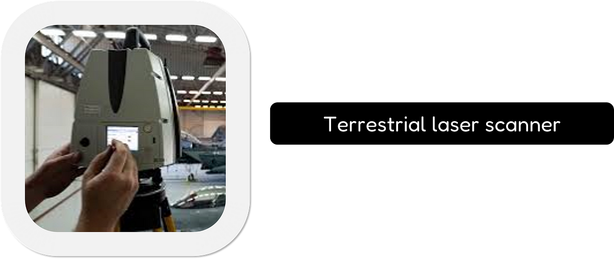
8. Terrestrial Laser Scanners (TLS)
Terrestrial laser scanners are my go-to when I need highly accurate, detailed 3D point cloud data for indoor industrial projects.
I use them for surveying, architectural documentation, civil engineering, or large industrial sites. They are precise, and they can provide very good data quality, along with very high-density data.
Recommended Material List:
- Terrestrial laser scanner (e.g., Leica ScanStation P20+, Trimble, Faro Focus series)
- Tripod for a stable setup
- Calibration targets (spheres, checkerboards)
- Data processing software (e.g., Cyclone, Scene)
Price Range:
- Laser scanner: $30,000 — $100,000+
- Tripod and targets: $200 — $1,000
- Software: $5,000 — $50,000+
9. Mobile Mapping Systems (MLS)
Mobile mapping systems are my preferred solution when I need to efficiently capture 3D data over large areas.
I use them for road surveys, urban mapping, railway asset management, and other large-scale infrastructure projects. These systems include both LiDAR and other sensors, all synchronized to deliver a very precise 3D model.
Recommended Material List:
- Mobile mapping system (LiDAR, cameras, GPS/IMU)
- Data processing software
Price Range:
- Mobile mapping system: $100,000 — $300,000+
- Software: $10,000 — $50,000+
10. GNSS Receivers for Precise Positioning (Photogrammetry and TLS)
GNSS receivers enhance the positional accuracy of 3D models in photogrammetry and TLS projects.
I use them when I need precise geo-referencing, and high accuracy of the 3D datasets. The primary use case is for large-scale projects requiring very high accuracy, such as urban mapping or surveying. I use it with scale bars and targets.
Recommended Material List:
- GNSS receiver (e.g., Trimble, Leica, Topcon)
- Tripod or mounting hardware
- Post-processing software
Price Range:
- GNSS receiver: $2,000 — $30,000+
- Software: $0 — $5,000+
11. RADAR (Radio Detection and Ranging) Systems (3D Reconstruction Methods)
RADAR systems are most useful when other systems are limited.
These are best suited for low visibility situations such as night time, foggy weather, or areas with limited light. They can also penetrate through some materials, making them ideal for certain subsurface investigations. These sensors are mostly used for long-distance scanning or large area mapping.
Recommended Material List:
- RADAR system
- Processing software
Price Range:
- RADAR system: $20,000 — $500,000+ ( depending on resolution, and range)
- Software: $1,000 — $50,000+
🦚 Note: Keep in mind that these prices can vary depending on the brand, features and resolution, and your location. The software costs can also change depending if you are subscribing or purchasing a perpetual license.
🌱 Growing: The current research is mainly focused on improving reconstruction accuracy and efficiency, often combining different sensor types (data fusion). There’s a growing interest in real-time reconstruction using embedded devices and mobile systems. Also, advancements in AI algorithms such as Neural Radiance Fields (NeRFs) are making it possible to reconstruct complex scenes with much higher detail, or visual fidelity (see 3D Gaussian Splatting). Methods to reduce the cost of 3D scanners are constantly being investigated, to enable an easier access to the technology by professionals, hobbyists, and researchers.
Okay, you now have your data and can reconstruct your 3D Models, and a way to select the best tool for the job, as seen below.
3D Reconstruction Methods: Conclusion
The ever-evolving landscape of 3D data science demands a comprehensive toolbox to handle various tasks effectively. This article serves as the first chapter in your journey towards building your own “3D Master Toolbox.”
We’ve explored the critical initial steps:
3D Data Curation (Bucket 1, Tools 1-4): We learned how to identify and source high-quality 3D data from various platforms like 3DCityLoader, OpenTopography, Sketchfab, and external sources like Mappillary. This ensures a solid foundation for your downstream processes.
3D Reconstruction Methods (Bucket 2, Tools 5-11): We delved into the world of 3D reconstruction, exploring techniques like photogrammetry and LiDAR scanning. Hardware options were presented, ranging from cost-effective smartphone cameras to high-precision terrestrial laser scanners. You’re now equipped to select the most suitable tool based on your project’s requirements and budget.
This is just the beginning! Stay tuned for the following chapters, where we’ll delve deeper into the remaining buckets of your “3D Master Toolbox,” including:
- Processing, Visualization & Editing Tools
- Programming Languages & Scripting
- Cloud-Based Solutions & APIs
- Communication & Collaboration Tools
- AI-powered Tools & Machine Learning
- Future Trends in 3D Data Science
By following this structured approach and incorporating the valuable resources compiled throughout this article, you’ll be well on your way to mastering the art of 3D data processing and creating groundbreaking innovations.
Remember, it’s not just about acquiring tools; it’s about understanding the underlying concepts and how they connect. This framework empowers you with both the practical know-how and the conceptual understanding to excel in the 3D space.
About the author
Florent Poux is a Scientific and Course Director focused on educating engineers on leveraging AI and 3D Data Science. He leads research teams and teaches 3D Computer Vision at various universities. His current aim is to ensure humans are correctly equipped with the knowledge and skills to tackle 3D challenges for impactful innovations.
Resources
- 🏆Awards: Jack Dangermond Award
- 📕Book: 3D Data Science with Python
- 📜Research: 3D Smart Point Cloud (Thesis)
- 🎓Courses: 3D Geodata Academy Catalog
- 💻Code: Florent’s Github Repository
- 💌3D Tech Digest: Weekly Newsletter
🦊 Florent: If you want to deepen your skills, I recommend the comprehensive course “Segmentor OS. ” In it, we implement these concepts hands-on and explore advanced optimization techniques for real-world projects.
Other 3D Tutorials
You can pick another Open-Access Tutorial to perfect your 3D Craft.
- 3D Pipeline Architecture: A Founder’s Blueprint
- Multi-View Engine for 3D Generative AI Models (Python Tutorial)
- 3D Scene Graphs for Spatial AI with NetworkX and OpenUSD
- 3D Reconstruction Pipeline: Photo to Model Workflow Guide
- Synthetic Point Cloud Generation of Rooms: Complete 3D Python Tutorial
- 3D Generative AI: 11 Tools (Cloud) for 3D Model Generation
- 3D Gaussian Splatting: Hands-on Course for Beginners
- Building a 3D Object Recognition Algorithm: A Step-by-Step Guide
- 3D Sensors Guide: Active vs. Passive Capture
- 3D Mesh from Point Cloud: Python with Marching Cubes Tutorial
- How To Generate GIFs from 3D Data with Python
- 3D Reconstruction from a Single Image: Tutorial
- 3D Reconstruction Methods, Hardware and Tools for 3D Data Processing
- 3D Deep Learning Essentials: Ressources, Roadmaps and Systems
- Tutorial for 3D Semantic Segmentation with Superpoint Transformer